
Gracias por apoyar a este sitio ❤️
Haz una donación
Haz una donación
Mapa topográfico Ethe
Haga clic en el mapa para ver la altitud.
Gracias por apoyar a este sitio ❤️
Haz una donación
Haz una donación
Acerca de este mapa
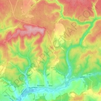
Nombre: Mapa topográfico Ethe, altitud, relieve.
Lugar: Ethe, Virton, Luxembourg, Wallonie, 6760, Belgique (49.57154 5.54974 49.63943 5.63085)
Altitud media: 293 m
Altitud mínima: 205 m
Altitud máxima: 384 m
Gracias por apoyar a este sitio ❤️
Haz una donación
Haz una donación
Otros mapas topográficos
Haga clic en un mapa para ver su topografía, su altitud y su relieve.