
Gracias por apoyar a este sitio ❤️
Haz una donación
Haz una donación
Mapa topográfico Har Reihan
Haga clic en el mapa para ver la altitud.
Gracias por apoyar a este sitio ❤️
Haz una donación
Haz una donación
Acerca de este mapa
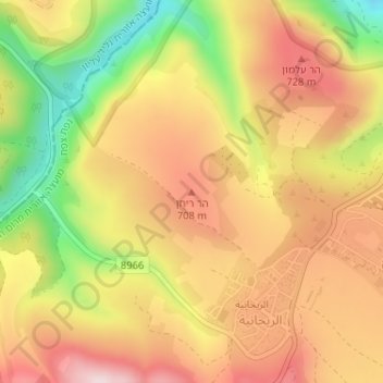
Nombre: Mapa topográfico Har Reihan, altitud, relieve.
Altitud media: 634 m
Altitud mínima: 424 m
Altitud máxima: 790 m
Gracias por apoyar a este sitio ❤️
Haz una donación
Haz una donación
Otros mapas topográficos
Haga clic en un mapa para ver su topografía, su altitud y su relieve.
Meron
Israel > North District > Merom HaGalil Regional Council
Meron is noted for its mountainous terrain and valleys. Among the local attractions are the Meron Vineyards. Meron is conducive to growing grapes for wine as a result of its 600-meter altitude and chalky soil. The vineyard was first planted in 2000 and is part of the Galil Mountain Winery, headquartered in…
Altitud media: 735 m
Gracias por apoyar a este sitio ❤️
Haz una donación
Haz una donación