
Mapa topográfico Ben Nevis
Mapa interactivo
Haga clic en el mapa para ver la altitud.
Acerca de este mapa
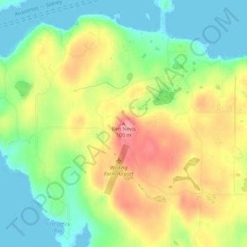
Nombre: Mapa topográfico Ben Nevis, altitud, relieve.
Altitud media: 49 m
Altitud mínima: 0 m
Altitud máxima: 112 m
Otros mapas topográficos
Haga clic en un mapa para ver su topografía, su altitud y su relieve.
San Juan Islands National Wildlife Refuge
United States > Washington > San Juan County
San Juan Islands National Wildlife Refuge, San Juan County, Washington, United States
Altitud media: 24 m
Eastsound
United States > Washington > San Juan County
Eastsound, San Juan County, Washington, United States, Orcas Island
Altitud media: 59 m
O'Neal Island
United States > Washington > San Juan County
O'Neal Island, San Juan County, Washington, United States
Altitud media: 18 m
Friday Harbor
United States > Washington > San Juan County
Friday Harbor, San Juan County, Washington, 98250, United States
Altitud media: 28 m
Spencer Lake
United States > Washington > San Juan County > Thatcher
Spencer Lake, Thatcher, San Juan County, Washington, United States
Altitud media: 150 m
Eastsound
United States > Washington > San Juan County
Eastsound, San Juan County, Washington, 98245, United States
Altitud media: 74 m