
Gracias por apoyar a este sitio ❤️
Haz una donación
Haz una donación
Mapa topográfico Jawhar
Haga clic en el mapa para ver la altitud.
Gracias por apoyar a este sitio ❤️
Haz una donación
Haz una donación
Jawhar
Jawhar is a hill station at 19°55′N 73°14′E / 19.92°N 73.23°E / 19.92; 73.23. Jawhar taluka is tropical and mostly surrounded by deciduous green plants. It has an average elevation of 447 metres (1466 feet). It is about 80 km from Nashik and about 145 km from Mumbai by road.
Gracias por apoyar a este sitio ❤️
Haz una donación
Haz una donación
Acerca de este mapa
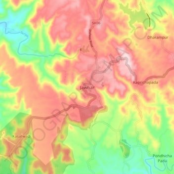
Nombre: Mapa topográfico Jawhar, altitud, relieve.
Lugar: Jawhar, Jawhar Taluka, Palghar, Maharashtra, 401603, India (19.87248 73.18516 19.95248 73.26516)
Altitud media: 377 m
Altitud mínima: 210 m
Altitud máxima: 514 m
Gracias por apoyar a este sitio ❤️
Haz una donación
Haz una donación