
Haz una donación
Mapa topográfico Cairns
Haga clic en el mapa para ver la altitud.
Haz una donación
Cairns
South of Smithfield and inland from the Northern Beaches along the edge of the Barron River flood plain are the suburbs of Caravonica, Kamerunga, Freshwater, and Stratford. This area is sometimes referred to as Freshwater Valley, though it is actually the lower part of Redlynch Valley; further up the valley are the suburbs of Redlynch, on the western side of Redlynch Valley, and Brinsmead on the eastern side. Stratford, Freshwater, and Brinsmead are separated from Cairns city by Mount Whitfield (elevation 365 m (1,198 ft)) and Whitfield Range. Crystal Cascades and Copperlode Falls Dam are also behind this range. (Kuranda, a town on the Barron River on the western side of the Macalister Range, forms part of the Cairns economic catchment but is in the Tablelands local government area and is not part of the Cairns urban area.)
Haz una donación
Acerca de este mapa
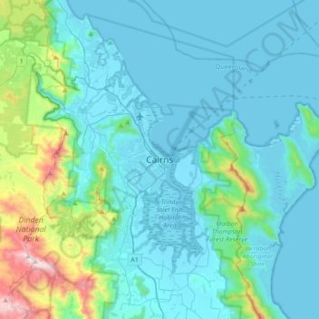
Nombre: Mapa topográfico Cairns, altitud, relieve.
Lugar: Cairns, Cairns Regional, Queensland, 4870, Australia (-17.08067 145.61219 -16.76067 145.93219)
Altitud media: 176 m
Altitud mínima: -1 m
Altitud máxima: 1,284 m
Haz una donación
Otros mapas topográficos
Haga clic en un mapa para ver su topografía, su altitud y su relieve.
City of Brisbane
Brisbane's topography is characterized by a series of hills and ranges that define its landscape. The city is situated on a low-lying floodplain, with the Brisbane River meandering through its heart, creating a winding course with many steep curves from the southwest to its mouth at Moreton Bay in the east.…
Altitud media: 71 m
Haz una donación
Mount Coot-tha
Australia > Queensland > City of Brisbane
It is often claimed that Mount Coot-tha is the "highest point in Brisbane", but, as the elevations above show, the peak known as Mount Coot-tha is not even the highest peak of the mountain as a whole with both Constitution Hill and The Summit being higher. However, Mount Coot-tha has a lookout with unobscured…
Altitud media: 88 m
Brisbane River
The RAAF also perform a practice session in the days preceding the event, serving as an opportunity to both practice beforehand and also promote Riverfire. One of the most popular RAAF aircraft to perform at Riverfire was the F-111 which was known for performing a 'dump-and-burn' above the city. The final…
Altitud media: 235 m
Haz una donación
Haz una donación
Alexandra Hills
Scribbly Gums Conservation Area is located on the eastern edge of Alexandra Hills, bordered by Redland Hospital to the east, and Flinders St and Winchester Rd to the north. The conservation area occupies approximately 152 hectares and contains the Redlands Track Park - a collection of 30+ mountain bike trails…
Altitud media: 34 m
Haz una donación
Haz una donación
Haz una donación
Sunshine Coast Regional
The Sunshine Coast Regional area in Queensland, Australia, features a diverse topography that ranges from coastal plains to rugged hinterlands. Along the coastline, the terrain is predominantly flat, with average elevations around 20 meters (66 feet) above sea level. Inland, the landscape transitions to…
Altitud media: 56 m
Haz una donación
Haz una donación
Haz una donación
Haz una donación
Stanthorpe
Owing to its elevation, Stanthorpe features a subtropical highland climate (Cfb). At an altitude of 811 metres (2,661 ft), Stanthorpe holds the record for the lowest temperature recorded in Queensland at −10.6 °C (12.9 °F) on 23 June 1961.
Altitud media: 831 m
Haz una donación
Haz una donación
Lama Lama National Park (Cape York Peninsula Aboriginal Land)
Altitud media: 86 m
Haz una donación
Haz una donación
Haz una donación
Haz una donación
Haz una donación
Highvale
The area is the headwaters of the South Pine River. In the north and west of the locality the elevation rises to heights greater than 500 m above sea level along the D'Aguilar Range. Highvale is positioned at the base of Mount Nebo and Mount Glorious.
Altitud media: 251 m
Haz una donación
Haz una donación
Haz una donación
Haz una donación
Haz una donación
Haz una donación
Haz una donación
Lamb Island
The island is in the southern part of Moreton Bay between the Queensland mainland and North Stradbroke Island. It is within the Moreton Bay Marine Park. The elevation ranges from 0 to 26 metres (0 to 85 ft) above sea level. The land use on the island is predominantly residential.
Altitud media: 4 m
Haz una donación