
Mapa topográfico Le Village Nègre
Mapa interactivo
Haga clic en el mapa para ver la altitud.
Acerca de este mapa
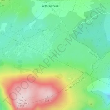
Nombre: Mapa topográfico Le Village Nègre, altitud, relieve.
Altitud media: 1,017 m
Altitud mínima: 879 m
Altitud máxima: 1,265 m
Otros mapas topográficos
Haga clic en un mapa para ver su topografía, su altitud y su relieve.
Saint-Barnabé
France > Provence-Alpes-Côte d'Azur > Alpes-Maritimes > Courmes
Saint-Barnabé, Courmes, Grasse, Alpes-Maritimes, Provence-Alpes-Côte d'Azur, France métropolitaine, 06620, France
Altitud media: 1,008 m
Le Village Nègre
France > Provence-Alpes-Côte d'Azur > Alpes-Maritimes > Courmes
Le Village Nègre, Courmes, Grasse, Alpes-Maritimes, Provence-Alpes-Côte d'Azur, France métropolitaine, 06620, France
Altitud media: 985 m
Bramafan
France > Provence-Alpes-Côte d'Azur > Alpes-Maritimes > Courmes
Bramafan, Courmes, Grasse, Alpes-Maritimes, Provence-Alpes-Côte d'Azur, France métropolitaine, 06620, France
Altitud media: 803 m
Le Village Nègre
France > Provence-Alpes-Côte d'Azur > Alpes-Maritimes > Courmes
Le Village Nègre, Courmes, Grasse, Alpes-Maritimes, Provence-Alpes-Côte d'Azur, France métropolitaine, 06620, France
Altitud media: 988 m