
Gracias por apoyar a este sitio ❤️
Haz una donación
Haz una donación
Mapa topográfico Dresden
Haga clic en el mapa para ver la altitud.
Gracias por apoyar a este sitio ❤️
Haz una donación
Haz una donación
Acerca de este mapa
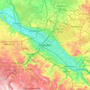
Nombre: Mapa topográfico Dresden, altitud, relieve.
Lugar: Dresden, Saxony, 01069, Germany (50.88933 13.57814 51.20933 13.89814)
Altitud media: 237 m
Altitud mínima: 97 m
Altitud máxima: 498 m
Gracias por apoyar a este sitio ❤️
Haz una donación
Haz una donación
Otros mapas topográficos
Haga clic en un mapa para ver su topografía, su altitud y su relieve.
Innere Altstadt
Dresden lies on both banks of the Elbe, mostly in the Dresden Basin, with the further reaches of the eastern Ore Mountains to the south, the steep slope of the Lusatian granitic crust to the north, and the Elbe Sandstone Mountains to the east at an altitude of about 113 metres (371 feet). Triebenberg is the…
Altitud media: 117 m
Gracias por apoyar a este sitio ❤️
Haz una donación
Haz una donación