
Mapa topográfico Cedarhurst
Mapa interactivo
Haga clic en el mapa para ver la altitud.
Acerca de este mapa
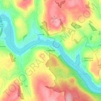
Nombre: Mapa topográfico Cedarhurst, altitud, relieve.
Altitud media: 111 m
Altitud mínima: 23 m
Altitud máxima: 201 m
Otros mapas topográficos
Haga clic en un mapa para ver su topografía, su altitud y su relieve.
Dodgingtown
United States > Connecticut > Western Connecticut Planning Region > Newtown
Dodgingtown, Newtown, Western Connecticut Planning Region, Connecticut, 06470, United States
Altitud media: 180 m
Hattertown
United States > Connecticut > Western Connecticut Planning Region > Newtown
Hattertown, Newtown, Western Connecticut Planning Region, Connecticut, United States
Altitud media: 182 m
Hawleyville
United States > Connecticut > Western Connecticut Planning Region > Newtown
Hawleyville, Newtown, Western Connecticut Planning Region, Connecticut, 01103, United States
Altitud media: 145 m
Sandy Hook
United States > Connecticut > Western Connecticut Planning Region > Newtown
Sandy Hook, Newtown, Western Connecticut Planning Region, Connecticut, 01103, United States
Altitud media: 113 m
Botsford
United States > Connecticut > Western Connecticut Planning Region > Newtown
Botsford, Newtown, Western Connecticut Planning Region, Connecticut, 06482, United States
Altitud media: 140 m