
Mapa topográfico Sarez Lake
Mapa interactivo
Haga clic en el mapa para ver la altitud.
Acerca de este mapa
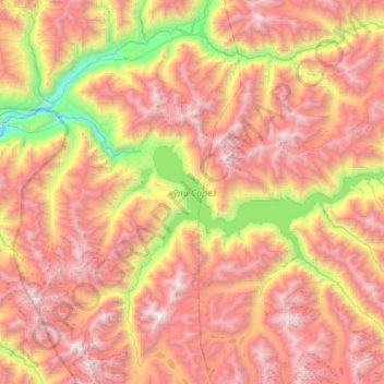
Nombre: Mapa topográfico Sarez Lake, altitud, relieve.
Altitud media: 4,302 m
Altitud mínima: 2,565 m
Altitud máxima: 5,886 m
Sarez Lake (Tajik: Сарез кӯл, romanized: Sarez Kūl) is a lake in Rushon District of Gorno-Badakhshan province, Tajikistan. Length about 75.8 kilometres (47.1 mi), depth few hundred meters, water surface elevation about 3,263 metres (10,705 ft) above sea level and volume of water is more than 16 cubic kilometres (3.8 cu mi). The mountains around rise more than 2,300 metres (7,500 ft) above the lake level.
Otros mapas topográficos
Haga clic en un mapa para ver su topografía, su altitud y su relieve.
Independence Peak
Tajikistan > Gorno-Badakhshan Autonomous Region > Rushon District
Independence Peak, Rushon District, Gorno-Badakhshan Autonomous Region, Tajikistan
Altitud media: 6,373 m
Rushon
Tajikistan > Gorno-Badakhshan Autonomous Region > Rushon District
Rushon, Rushon District, Gorno-Badakhshan Autonomous Region, Tajikistan
Altitud media: 2,613 m