
Gracias por apoyar a este sitio ❤️
Haz una donación
Haz una donación
Mapa topográfico Mount Kalatungan
Haga clic en el mapa para ver la altitud.
Gracias por apoyar a este sitio ❤️
Haz una donación
Haz una donación
Mount Kalatungan
Mount Kalatungan is the fifth highest mountain in the country with an elevation of 2,880 m (9,450 ft) asl. It is one of the several high elevation peaks in the Kalatungan Mountain Range in Bukidnon on the island of Mindanao, the second largest island in the Philippines.
Gracias por apoyar a este sitio ❤️
Haz una donación
Haz una donación
Acerca de este mapa
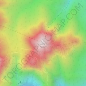
Nombre: Mapa topográfico Mount Kalatungan, altitud, relieve.
Altitud media: 2,481 m
Altitud mínima: 2,079 m
Altitud máxima: 2,864 m
Gracias por apoyar a este sitio ❤️
Haz una donación
Haz una donación
Otros mapas topográficos
Haga clic en un mapa para ver su topografía, su altitud y su relieve.