
Mapa topográfico Lemnos
Mapa interactivo
Haga clic en el mapa para ver la altitud.
Acerca de este mapa
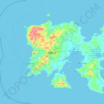
Nombre: Mapa topográfico Lemnos, altitud, relieve.
Lugar: Lemnos, Lemnos Regional Unit, Northern Aegean, Aegean, Greece (39.78170 25.03318 40.03604 25.44722)
Altitud media: 27 m
Altitud mínima: 0 m
Altitud máxima: 430 m
Otros mapas topográficos
Haga clic en un mapa para ver su topografía, su altitud y su relieve.
Kotsinas Beach
Greece > Aegean > Lemnos Regional Unit > Κότσινας
Kotsinas Beach, Κότσινας, Lemnos Municipality, Lemnos Regional Unit, Northern Aegean, Aegean, 814 01, Greece
Altitud media: 15 m
Σαρδές
Greece > Aegean > Lemnos Regional Unit
Σαρδές, Lemnos Municipality, Lemnos Regional Unit, Northern Aegean, Aegean, 814 00, Greece
Altitud media: 191 m
Myrina
Greece > Aegean > Lemnos Regional Unit
Myrina, Lemnos Municipality, Lemnos Regional Unit, Northern Aegean, Aegean, 814 00, Greece
Altitud media: 39 m
Agios Efstratios
Greece > Aegean > Lemnos Regional Unit > Agios Efstratios
Agios Efstratios, Agios Efstratios Municipality, Lemnos Regional Unit, Northern Aegean, Aegean, 815 00, Greece
Altitud media: 38 m
Athira
Greece > Aegean > Lemnos Regional Unit > Athira
Athira, Lemnos Municipality, Lemnos Regional Unit, Northern Aegean, Aegean, 81401, Greece
Altitud media: 32 m