
Haz una donación
Mapa topográfico Chaozhou
Haga clic en el mapa para ver la altitud.
Haz una donación
Chaozhou
The Chaozhou territory is mountainous. In particular, the nearby Phoenix Mountain's peak is located 1,497 meters (4,911 ft) above sea level. The main nearby rivers are the Huanggang River and the Han River. The Han River flows from west to southeast, and ramps through downtown Chaozhou; the Huanggang river flows roughly from north to south through the territory of Raoping, emptying into the sea. These two rivers provide abundant water for Chaozhou. Hills account for 65% of the total land area within the city, mainly in Raoping and Northern Chaoan. To the north of the city, there is a wide mountainous area suitable for tea cultivation; the lower-altitude areas nearby are mainly suitable for growing bamboo, peach, plum, olive, and pineapple. On the banks of the Han River, there is fertile land used for rice, sweet potato, peanut, soybean, carrot, orange, peach, and banana cultivation.
Haz una donación
Acerca de este mapa
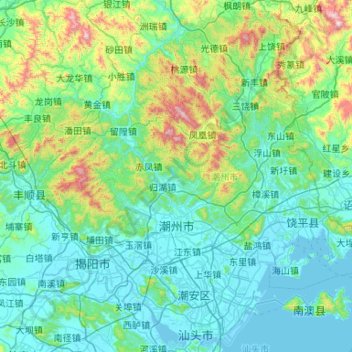
Nombre: Mapa topográfico Chaozhou, altitud, relieve.
Lugar: Chaozhou, Guangdong, China (23.42758 116.36375 24.23576 117.22214)
Altitud media: 229 m
Altitud mínima: -1 m
Altitud máxima: 1,501 m
Haz una donación
Otros mapas topográficos
Haga clic en un mapa para ver su topografía, su altitud y su relieve.
Mount Yangtai
The Mount Yangtai (Chinese: 羊台山; pinyin: Yángtaíshān), also known as Mount Yangtai Forest Park, is a mountain at the junction of Bao'an District and Nanshan District in Shenzhen, Guangdong, China. The peak is 587.3 metres (1,927 ft) in elevation, which is the highest peak in western Shenzhen. In 2008…
Altitud media: 287 m
Haz una donación
Haz una donación
Haz una donación
Haz una donación