
Haz una donación
Mapa topográfico Sawantwadi
Haga clic en el mapa para ver la altitud.
Haz una donación
Sawantwadi
Sawantwadi is located at 16°00′N 73°45′E / 16°N 73.75°E / 16; 73.75 in the Sindhudurg district of Maharashtra. It has an average elevation of 22 metres (72 ft) above mean sea level. It is the administrative headquarters of the Sindhudurg district. Sawantwadi is situated on the west coast of Maharashtra, India, and is bounded by the Arabian Sea to its west and the Western Ghats to its east. As a municipal entity, it spans an area of 132.45 km2 (51.14 sq mi), and experiences moderate to gusty winds during the day and gentle winds at night. The topography of the city ranges from plain to undulating, with several hills, valleys and flat areas within the city. The geology of the city is characterised by hard laterite in hilly tracts and sandy soil along the seashore.
Haz una donación
Acerca de este mapa
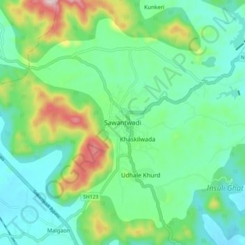
Nombre: Mapa topográfico Sawantwadi, altitud, relieve.
Altitud media: 116 m
Altitud mínima: 19 m
Altitud máxima: 380 m
Haz una donación