
Gracias por apoyar a este sitio ❤️
Haz una donación
Haz una donación
Mapa topográfico Boyd
Haga clic en el mapa para ver la altitud.
Gracias por apoyar a este sitio ❤️
Haz una donación
Haz una donación
Acerca de este mapa
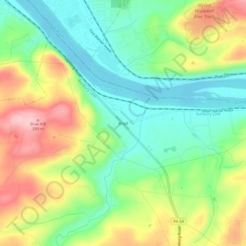
Nombre: Mapa topográfico Boyd, altitud, relieve.
Altitud media: 198 m
Altitud mínima: 128 m
Altitud máxima: 303 m
Gracias por apoyar a este sitio ❤️
Haz una donación
Haz una donación
Otros mapas topográficos
Haga clic en un mapa para ver su topografía, su altitud y su relieve.
Mount Carmel
United States > Pennsylvania > Northumberland County
Sawmill operator, Albert Bradford, gave Mount Carmel its name because of its elevation and beautiful setting in the mountains. He decided that it deserved a special name and named it after the holy mountain in Israel. Mount Carmel began as a logging town. Coal was only discovered in 1790 by Isaac Tomlinson. It…
Altitud media: 380 m
Gracias por apoyar a este sitio ❤️
Haz una donación
Haz una donación
Gracias por apoyar a este sitio ❤️
Haz una donación
Haz una donación