
Mapa topográfico Sevington
Mapa interactivo
Haga clic en el mapa para ver la altitud.
Acerca de este mapa
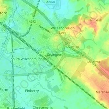
Nombre: Mapa topográfico Sevington, altitud, relieve.
Lugar: Sevington, Ashford, Kent, England, TN24 0LE, United Kingdom (51.11327 0.88405 51.15327 0.92405)
Altitud media: 46 m
Altitud mínima: 30 m
Altitud máxima: 76 m
Otros mapas topográficos
Haga clic en un mapa para ver su topografía, su altitud y su relieve.
Orlestone
United Kingdom > England > Kent > Ashford
Orlestone, Ashford, Kent, England, United Kingdom
Altitud media: 25 m
Boughton Aluph
United Kingdom > England > Kent > Ashford > Boughton Lees
Boughton Aluph, Boughton Lees, Ashford, Kent, England, United Kingdom
Altitud media: 78 m
Flip Out
United Kingdom > England > Kent > Ashford
Flip Out, Henwood, Henwood Industrial Estate, Willesborough, Ashford, Kent, England, TN24 8DH, United Kingdom
Altitud media: 43 m
Potters Corner
United Kingdom > England > Kent > Ashford
Potters Corner, Westwell, Ashford, Kent, England, TN25 4QB, United Kingdom
Altitud media: 61 m
Bilsington
United Kingdom > England > Kent > Ashford > Bilsington
Bilsington, Ashford, Kent, England, United Kingdom
Altitud media: 25 m
Shadoxhurst
United Kingdom > England > Kent > Ashford > Shadoxhurst
Shadoxhurst, Ashford, Kent, England, United Kingdom
Altitud media: 43 m
Wye Downs
United Kingdom > England > Kent > Ashford
Wye Downs, Wye with Hinxhill, Ashford, Kent, England, TN25 5HX, United Kingdom
Altitud media: 118 m
Brook
United Kingdom > England > Kent > Ashford
Brook, Ashford, Kent, England, United Kingdom
Altitud media: 57 m
Stonestreet Green
United Kingdom > England > Kent > Ashford > Aldington
Stonestreet Green, Aldington, Ashford, Kent, England, TN25 7DX, United Kingdom
Altitud media: 57 m
St Michaels
United Kingdom > England > Kent > Ashford
St Michaels, Ashford, Kent, England, TN30 6BY, United Kingdom
Altitud media: 41 m
Hastingleigh
United Kingdom > England > Kent > Ashford
Hastingleigh, Ashford, Kent, England, United Kingdom
Altitud media: 144 m
Aldington Frith
United Kingdom > England > Kent > Ashford
Aldington Frith, Ashford, Kent, England, TN25 7DQ, United Kingdom
Altitud media: 44 m
Upper Great Stour
United Kingdom > England > Kent > Ashford
Upper Great Stour, Ashford, Kent, England, TN27 9AX, United Kingdom
Altitud media: 87 m
Great Chart
United Kingdom > England > Kent > Ashford
Great Chart, Ashford, Kent, England, TN23 3AP, United Kingdom
Altitud media: 49 m
Charing
United Kingdom > England > Kent > Ashford
Charing, Ashford, Kent, England, United Kingdom
Altitud media: 122 m
Biddenden
United Kingdom > England > Kent > Ashford
Biddenden, Ashford, Kent, England, United Kingdom
Altitud media: 46 m
Westwell
United Kingdom > England > Kent > Ashford
Westwell, Ashford, Kent, England, United Kingdom
Altitud media: 98 m
Pluckley
United Kingdom > England > Kent > Ashford
Pluckley, Ashford, Kent, England, United Kingdom
Altitud media: 56 m
Wye National Nature Reserve
United Kingdom > England > Kent > Ashford > Brook
Wye National Nature Reserve, Amage Road, Wye with Hinxhill, Brook, Ashford, Kent, England, TN25 5DF, United Kingdom
Altitud media: 123 m
Stone-cum-Ebony
United Kingdom > England > Kent > Ashford
Stone-cum-Ebony, Ashford, Kent, England, United Kingdom
Altitud media: 12 m
Egerton Forstal
United Kingdom > England > Kent > Ashford > Egerton Forstal
Egerton Forstal, Egerton, Ashford, Kent, England, TN27 9EL, United Kingdom
Altitud media: 50 m
Wittersham
United Kingdom > England > Kent > Ashford
Wittersham, Ashford, Kent, England, United Kingdom
Altitud media: 18 m
Egerton
United Kingdom > England > Kent > Ashford
Egerton, Ashford, Kent, England, United Kingdom
Altitud media: 63 m
Small Hythe
United Kingdom > England > Kent > Ashford
Small Hythe, Tenterden, Ashford, Kent, England, TN30 7NF, United Kingdom
Altitud media: 26 m
Rolvenden
United Kingdom > England > Kent > Ashford
Rolvenden, Ashford, Kent, England, United Kingdom
Altitud media: 31 m
Kingsnorth
United Kingdom > England > Kent > Ashford > Kingsnorth
Kingsnorth, Ashford, Kent, England, United Kingdom
Altitud media: 43 m
Smarden
United Kingdom > England > Kent > Ashford
Smarden, Ashford, Kent, England, United Kingdom
Altitud media: 31 m
Appledore
United Kingdom > England > Kent > Ashford
Appledore, Ashford, Kent, England, United Kingdom
Altitud media: 9 m
Stubbs Cross
United Kingdom > England > Kent > Ashford
Stubbs Cross, Ashford, Kent, England, TN26 1HH, United Kingdom
Altitud media: 43 m
Newenden
United Kingdom > England > Kent > Ashford
Newenden, Ashford, Kent, England, United Kingdom
Altitud media: 10 m
Wye
United Kingdom > England > Kent > Ashford
Wye, Ashford, Kent, England, TN25 5GW, United Kingdom
Altitud media: 55 m
Woodchurch
United Kingdom > England > Kent > Ashford > Woodchurch
Woodchurch, Ashford, Kent, England, United Kingdom
Altitud media: 28 m
Mersham
United Kingdom > England > Kent > Ashford
Mersham, Ashford, Kent, England, United Kingdom
Altitud media: 55 m
Cheeseman's Green
United Kingdom > England > Kent > Ashford
Cheeseman's Green, Ashford, Kent, England, TN25 7HY, United Kingdom
Altitud media: 44 m
Chilham
United Kingdom > England > Kent > Ashford
Chilham, Ashford, Kent, England, United Kingdom
Altitud media: 72 m
Warehorne
United Kingdom > England > Kent > Ashford
Warehorne, Ashford, Kent, England, United Kingdom
Altitud media: 20 m
High Halden
United Kingdom > England > Kent > Ashford
High Halden, Ashford, Kent, England, United Kingdom
Altitud media: 37 m
Aldington
United Kingdom > England > Kent > Ashford
Aldington, Ashford, Kent, England, United Kingdom
Altitud media: 40 m
Tenterden
United Kingdom > England > Kent > Ashford
Tenterden, Ashford, Kent, England, United Kingdom
Altitud media: 28 m
Bethersden
United Kingdom > England > Kent > Ashford > Bethersden
Bethersden, Ashford, Kent, England, United Kingdom
Altitud media: 38 m
Kennington
United Kingdom > England > Kent > Ashford
Kennington, Ashford, Kent, England, United Kingdom
Altitud media: 47 m
Challock
United Kingdom > England > Kent > Ashford
Challock, Ashford, Kent, England, United Kingdom
Altitud media: 136 m
Bromley Green
United Kingdom > England > Kent > Ashford
Bromley Green, Ruckinge, Ashford, Kent, England, TN26 2EG, United Kingdom
Altitud media: 44 m
Old Wives Lees
United Kingdom > England > Kent > Ashford
Old Wives Lees, Ashford, Kent, England, CT4 8AP, United Kingdom
Altitud media: 66 m
Brabourne
United Kingdom > England > Kent > Ashford
Brabourne, Ashford, Kent, England, United Kingdom
Altitud media: 93 m
Hamstreet
United Kingdom > England > Kent > Ashford
Hamstreet, Ashford, Kent, England, TN26 2HE, United Kingdom
Altitud media: 22 m
Stone in Oxney
United Kingdom > England > Kent > Ashford
Stone in Oxney, Ashford, Kent, England, TN30 7JS, United Kingdom
Altitud media: 12 m