
Gracias por apoyar a este sitio ❤️
Haz una donación
Haz una donación
Mapa topográfico Stendal
Haga clic en el mapa para ver la altitud.
Gracias por apoyar a este sitio ❤️
Haz una donación
Haz una donación
Stendal
Aland | Altmärkische Höhe | Altmärkische Wische | Eichstedt (Altmark) | Goldbeck | Hassel | Hohenberg-Krusemark | Iden | Kamern | Klietz | Rochau | Schollene | Schönhausen (Elbe) | Wust-Fischbeck | Zehrental
Gracias por apoyar a este sitio ❤️
Haz una donación
Haz una donación
Acerca de este mapa
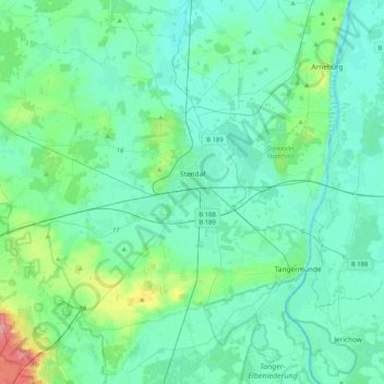
Nombre: Mapa topográfico Stendal, altitud, relieve.
Lugar: Stendal, Sachsen-Anhalt, 39576, Deutschland (52.48478 11.56867 52.70079 11.97921)
Altitud media: 41 m
Altitud mínima: 24 m
Altitud máxima: 133 m
Gracias por apoyar a este sitio ❤️
Haz una donación
Haz una donación
Otros mapas topográficos
Haga clic en un mapa para ver su topografía, su altitud y su relieve.
Gutshaus Hohenwulsch
Deutschland > Sachsen-Anhalt > Stendal > Bismark (Altmark) > Hohenwulsch
Altitud media: 55 m
Gracias por apoyar a este sitio ❤️
Haz una donación
Haz una donación
Schnöggersburg (Wüstung)
Deutschland > Sachsen-Anhalt > Stendal > Stendal > Staats
Altitud media: 100 m
Gracias por apoyar a este sitio ❤️
Haz una donación
Haz una donación
Gracias por apoyar a este sitio ❤️
Haz una donación
Haz una donación