
Haz una donación
Mapa topográfico Pune
Haga clic en el mapa para ver la altitud.
Haz una donación
Pune
Pune is situated at approximately 18° 32" north latitude and 73° 51" east longitude. The city's total area is 15.642 km2, and the municipal corporation area covers 518 km2. By road Pune is 149 km (93 mi) south-east of Mumbai, 580 km (360 mi) south-west of Indore, 695 km (432 mi) west of Nagpur, 1,173 km (729 mi) south of Delhi, 734 km (456 mi) north of Bangalore, 562 km (349 mi) north-west of Hyderabad. Pune lies on the western margin of the Deccan Plateau, at an altitude of 560 m (1,840 ft) above sea level. It is on the leeward side of the Sahyadri mountain range, which forms a barrier from the Arabian Sea. It is a hilly city, with Vetal Hill rising to 800 m (2,600 ft) above sea level. The Sinhagad fort is at an altitude of 1,300 metres (4,300 feet).
Haz una donación
Acerca de este mapa
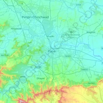
Nombre: Mapa topográfico Pune, altitud, relieve.
Lugar: Pune, Pune City, Pune District, Maharashtra, 411001, India (18.36137 73.69451 18.68137 74.01451)
Altitud media: 641 m
Altitud mínima: 526 m
Altitud máxima: 1,304 m
Haz una donación
Otros mapas topográficos
Haga clic en un mapa para ver su topografía, su altitud y su relieve.