
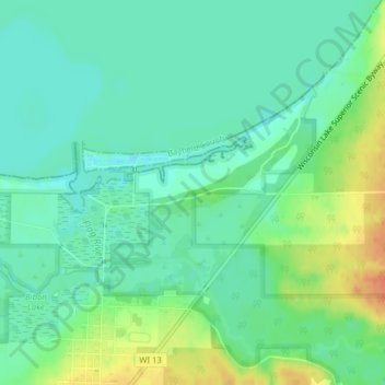
Mapa topográfico Boreal Forest
Mapa interactivo
Haga clic en el mapa para ver la altitud.
Acerca de este mapa
Nombre: Mapa topográfico Boreal Forest, altitud, relieve.
Altitud media: 185 m
Altitud mínima: 170 m
Altitud máxima: 214 m
Otros mapas topográficos
Haga clic en un mapa para ver su topografía, su altitud y su relieve.
Washburn
United States > Wisconsin > Bayfield County
Washburn, Bayfield County, Wisconsin, United States
Altitud media: 213 m
Grand View
United States > Wisconsin > Bayfield County
Grand View, Town of Grandview, Bayfield County, Wisconsin, 54839, United States
Altitud media: 314 m
Barksdale
United States > Wisconsin > Bayfield County
Barksdale, Town of Barksdale, Bayfield County, Wisconsin, 54806, United States
Altitud media: 197 m
Drummond
United States > Wisconsin > Bayfield County
Drummond, Town of Drummond, Bayfield County, Wisconsin, United States
Altitud media: 402 m
Cornucopia
United States > Wisconsin > Bayfield County
Cornucopia, Town of Bell, Bayfield County, Wisconsin, 54827, United States
Altitud media: 212 m
Lund Lake
United States > Wisconsin > Bayfield County
Lund Lake, Town of Drummond, Bayfield County, Wisconsin, United States
Altitud media: 367 m
Port Wing
United States > Wisconsin > Bayfield County
Port Wing, Town of Port Wing, Bayfield County, Wisconsin, 54865, United States
Altitud media: 204 m
Stewart Lake
United States > Wisconsin > Bayfield County
Stewart Lake, Town of Drummond, Bayfield County, Wisconsin, United States
Altitud media: 443 m
Sioux River
United States > Wisconsin > Bayfield County
Sioux River, Town of Washburn, Bayfield County, Wisconsin, United States
Altitud media: 267 m
Mason
United States > Wisconsin > Bayfield County
Mason, Bayfield County, Wisconsin, United States
Altitud media: 293 m
Devils Lake
United States > Wisconsin > Bayfield County
Devils Lake, Town of Barnes, Bayfield County, Wisconsin, United States
Altitud media: 361 m
Bullhead Lake
United States > Wisconsin > Bayfield County
Bullhead Lake, Town of Grandview, Bayfield County, Wisconsin, United States
Altitud media: 451 m
Town of Washburn
United States > Wisconsin > Bayfield County
Town of Washburn, Bayfield County, Wisconsin, United States
Altitud media: 332 m
Town of Bayfield
United States > Wisconsin > Bayfield County
Town of Bayfield, Bayfield County, Wisconsin, 54814, United States
Altitud media: 244 m
Bayfield
United States > Wisconsin > Bayfield County
Bayfield, Bayfield County, Wisconsin, United States
Altitud media: 245 m
Delta
United States > Wisconsin > Bayfield County
Delta, Town of Delta, Bayfield County, Wisconsin, United States
Altitud media: 335 m
Town of Orienta
United States > Wisconsin > Bayfield County
Town of Orienta, Bayfield County, Wisconsin, United States
Altitud media: 227 m
Town of Clover
United States > Wisconsin > Bayfield County
Town of Clover, Bayfield County, Wisconsin, 54844, United States
Altitud media: 274 m
Herbster
United States > Wisconsin > Bayfield County
Herbster, Town of Clover, Bayfield County, Wisconsin, 54844, United States
Altitud media: 196 m
Iron River
United States > Wisconsin > Bayfield County
Iron River, Town of Oulu, Bayfield County, Wisconsin, United States
Altitud media: 289 m
Cable
United States > Wisconsin > Bayfield County
Cable, Town of Cable, Bayfield County, Wisconsin, United States
Altitud media: 418 m