
Gracias por apoyar a este sitio ❤️
Haz una donación
Haz una donación
Mapa topográfico Eagle Nest WLS
Haga clic en el mapa para ver la altitud.
Gracias por apoyar a este sitio ❤️
Haz una donación
Haz una donación
Acerca de este mapa
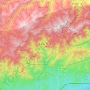
Nombre: Mapa topográfico Eagle Nest WLS, altitud, relieve.
Altitud media: 1,680 m
Altitud mínima: 149 m
Altitud máxima: 3,247 m
Gracias por apoyar a este sitio ❤️
Haz una donación
Haz una donación
Otros mapas topográficos
Haga clic en un mapa para ver su topografía, su altitud y su relieve.
Sessa Orchid Sanctuary
India > Arunachal Pradesh > Bhalukpong EAC
Sessa sanctuary is drained by the Tippi Naala (Tippi river), which joins the Kameng river at Tippi village on the Bhalukpong-Bomdila highway. Topographic map
Altitud media: 1,414 m