
Gracias por apoyar a este sitio ❤️
Haz una donación
Haz una donación
Mapa topográfico Akluj
Haga clic en el mapa para ver la altitud.
Gracias por apoyar a este sitio ❤️
Haz una donación
Haz una donación
Akluj
Akluj is in Malshiras tehsil and is 120 km (75 mi) away from Solapur city. It is located on the right bank of Nira River. The elevation of Akluj is 551 m (1,808 ft). The latitude 17.9000 and longitude 75.0333. The altitude in feet 1581 Lat (DMS) north 17° 53' 60 N Long (DMS) east 75° 1' 60E altitude (meters) 481.
Gracias por apoyar a este sitio ❤️
Haz una donación
Haz una donación
Acerca de este mapa
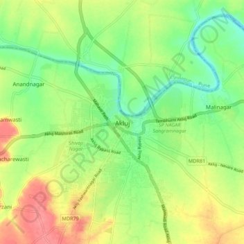
Nombre: Mapa topográfico Akluj, altitud, relieve.
Lugar: Akluj, Malshiras, Solapur District, Maharashtra, 413101, India (17.85301 74.98045 17.93301 75.06045)
Altitud media: 491 m
Altitud mínima: 461 m
Altitud máxima: 529 m
Gracias por apoyar a este sitio ❤️
Haz una donación
Haz una donación
Otros mapas topográficos
Haga clic en un mapa para ver su topografía, su altitud y su relieve.