
Haz una donación
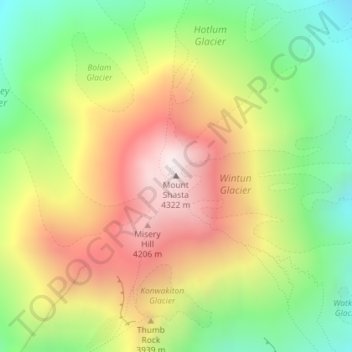
Mapa topográfico Mount Shasta
Haga clic en el mapa para ver la altitud.
Haz una donación
Mount Shasta
Mount Shasta (/ˈʃæstə/ SHASS-tə; Shasta: Waka-nunee-Tuki-wuki; Karuk: Úytaahkoo) is a potentially active volcano at the southern end of the Cascade Range in Siskiyou County, California. At an elevation of 14,179 ft (4,322 m), it is the second-highest peak in the Cascades and the fifth-highest in the state. Mount Shasta has an estimated volume of 85 cubic miles (350 cubic kilometers), which makes it the most voluminous stratovolcano in the Cascade Volcanic Arc. The mountain and surrounding area are part of the Shasta–Trinity National Forest.
Haz una donación
Acerca de este mapa
Nombre: Mapa topográfico Mount Shasta, altitud, relieve.
Lugar: Mount Shasta, Siskiyou County, California, United States (41.40915 -122.19491 41.40925 -122.19481)
Altitud media: 3,717 m
Altitud mínima: 3,194 m
Altitud máxima: 4,309 m
Haz una donación