
Haz una donación
Mapa topográfico Seaside
Haga clic en el mapa para ver la altitud.
Haz una donación
Seaside
Seaside, formerly East Monterey, is a city in Monterey County, California, United States, with a population of 32,366 as of the 2020 census. It is located 2.25 miles (3.6 km) east-northeast of Monterey, at an elevation of 33 feet (10 m), and is the home of California State University, Monterey Bay (CSUMB), UC MBEST Center, and the Monterey College of Law, which are located on the site of the former military base Fort Ord. Also on the site are the Bayonet and Black Horse golf courses, now open to the public and host to PGA Tour events, including the 2012 PGA Professional National Championship. Seaside is the gateway to Fort Ord National Monument, created on April 20, 2012.
Haz una donación
Acerca de este mapa
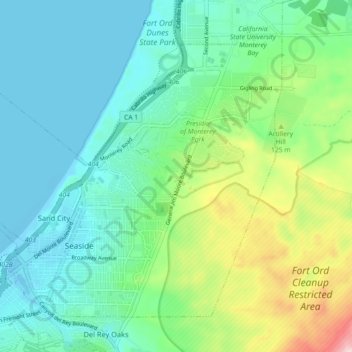
Nombre: Mapa topográfico Seaside, altitud, relieve.
Lugar: Seaside, Monterey County, California, 93955, United States (36.59681 -121.87991 36.65474 -121.78988)
Altitud media: 69 m
Altitud mínima: -7 m
Altitud máxima: 275 m
Haz una donación
Otros mapas topográficos
Haga clic en un mapa para ver su topografía, su altitud y su relieve.
Bradley
United States > California > Monterey County
Bradley is an unincorporated community and census-designated place (CDP) in Monterey County, California, on the Salinas River 14 miles (23 km) south-southeast of San Ardo and 20 miles (32 km) north of Paso Robles. Bradley sits at an elevation of 548 feet (167 m). The population was 69 at the 2020 census, down…
Altitud media: 190 m