
Haz una donación
Mapa topográfico Fort Collins
Haga clic en el mapa para ver la altitud.
Haz una donación
Fort Collins
Fort Collins is situated at the base of the Rocky Mountain foothills of the northern Front Range, approximately 60 miles (97 km) north of Denver, Colorado, and 45 miles (72 km) south of Cheyenne, Wyoming. Elevation is 4,982 ft (1,519 m) above sea level. Geographic landmarks include Horsetooth Reservoir and Horsetooth Mountain—so named because of a tooth-shaped granite rock that dominates the city's western skyline. Longs Peak can also clearly be seen on a clear day to the southwest of the city.
Haz una donación
Acerca de este mapa
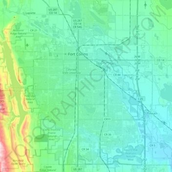
Nombre: Mapa topográfico Fort Collins, altitud, relieve.
Lugar: Fort Collins, Larimer County, Colorado, United States (40.47261 -105.15736 40.63935 -104.98200)
Altitud media: 1,560 m
Altitud mínima: 1,465 m
Altitud máxima: 2,084 m
Haz una donación
Otros mapas topográficos
Haga clic en un mapa para ver su topografía, su altitud y su relieve.
Estes Park
United States > Colorado > Larimer County
Estes Park sits at an elevation of 7,522 feet (2,293 m) on the front range of the Rocky Mountains at the eastern entrance of the Rocky Mountain National Park. Its north, south and east extremities border the Roosevelt National Forest. Lumpy Ridge lies immediately north of Estes Park.
Altitud media: 2,543 m
Haz una donación
Estes Park
United States > Colorado > Larimer County
Estes Park sits at an elevation of 7,522 feet (2,293 m) on the front range of the Rocky Mountains at the eastern entrance of the Rocky Mountain National Park. Its location is 40°22′22″N 105°31′09″W / 40.372856°N 105.519136°W / 40.372856; -105.519136. Its north, south and east extremities…
Altitud media: 2,543 m
Estes Park
United States > Colorado > Larimer County
Estes Park sits at an elevation of 7,522 feet (2,293 m) on the front range of the Rocky Mountains at the eastern entrance of the Rocky Mountain National Park. Its north, south and east extremities border the Roosevelt National Forest. Lumpy Ridge lies immediately north of Estes Park.
Altitud media: 2,420 m
Haz una donación
Stanley Heights Subdivision
United States > Colorado > Larimer County > Estes Park
Altitud media: 2,345 m
Haz una donación
Silver Lake
United States > Colorado > Larimer County > Loveland > Browns Corner
Altitud media: 1,524 m
Estes Park
United States > Colorado > Larimer County
Estes Park sits at an elevation of 7,522 feet (2,293 m) on the front range of the Rocky Mountains at the eastern entrance of the Rocky Mountain National Park. Its location is 40°22′22″N 105°31′09″W / 40.372856°N 105.519136°W / 40.372856; -105.519136. Its north, south and east extremities…
Altitud media: 2,409 m
Haz una donación
La Poudre Pass
United States > Colorado > Larimer County
La Poudre Pass (elevation 10,184 ft (3,104 m)), a high mountain pass, is located in the Rocky Mountains of northern Colorado in the United States.
Altitud media: 3,218 m
Haz una donación
Horseshoe Lake (South Dam)
United States > Colorado > Larimer County > Loveland
Altitud media: 1,515 m
Haz una donación
Estes Park
United States > Colorado > Larimer County
Estes Park sits at an elevation of 7,522 feet (2,293 m) on the front range of the Rocky Mountains at the eastern entrance of the Rocky Mountain National Park. Its north, south and east extremities border the Roosevelt National Forest. Lumpy Ridge lies immediately north of Estes Park.
Altitud media: 2,429 m
Haz una donación
Haz una donación
Stanley Heights Subdivision
United States > Colorado > Larimer County > Estes Park
Altitud media: 2,345 m
Haz una donación
Estes Park
United States > Colorado > Larimer County
Estes Park sits at an elevation of 7,658 feet (2,334 m) on the Front Range of the Rocky Mountains at the eastern entrance of the Rocky Mountain National Park. Its north, south and east extremities border the Roosevelt National Forest. Lumpy Ridge lies immediately north of Estes Park.
Altitud media: 2,543 m
Haz una donación
Haz una donación