
Haz una donación
Mapa topográfico Mount Lofty
Haga clic en el mapa para ver la altitud.
Haz una donación
Acerca de este mapa
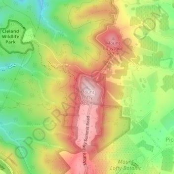
Nombre: Mapa topográfico Mount Lofty, altitud, relieve.
Altitud media: 554 m
Altitud mínima: 398 m
Altitud máxima: 709 m
Haz una donación
Otros mapas topográficos
Haga clic en un mapa para ver su topografía, su altitud y su relieve.
Adelaide
Australia > South Australia > Adelaide City Council
South Australia was officially established as a British Province in England in February 1836. The first governor proclaimed the commencement of colonial government in South Australia on 28 December 1836, near The Old Gum Tree in what is now the suburb of Glenelg North. The event is commemorated in South…
Altitud media: 146 m
Haz una donación
Haz una donación
Stirling
Many deciduous trees, particularly the maple, elm, oak and ash trees, have been imported from Europe and North America. These trees flourish in Stirling's wet and mild to cool climate and are a popular tourist attraction in the autumn months (April–May), bringing rich and vibrant autumn leaf colour to the…
Altitud media: 504 m
Haz una donación
Mount Barker
Australia > South Australia > Mount Barker District Council
Mount Barker is located on the plains surrounding the Mount Barker Summit, about 2 km west of the mountain itself, at 35°04′S 138°51′E / 35.067°S 138.850°E / -35.067; 138.850. Mount Barker is south east of Mount Lofty and Adelaide. It is to the north of The Coorong, and the west of Murray…
Altitud media: 368 m
Haz una donación
Haz una donación
Haz una donación
Haz una donación
Haz una donación
Mintaro
Mintaro is located in the eastern Clare Valley, about 126 km north of Adelaide, South Australia east of the Horrocks Highway. The town lies at the south-eastern corner of the Hundred of Clare, in the undulating hills of South Australia's Mid North, within the Clare Valley wine region. The region contains a…
Altitud media: 425 m
Haz una donación
Haz una donación
Haz una donación
Haz una donación
Haz una donación
Mount Barker
Australia > South Australia > Mount Barker District Council
Mount Barker is located on the plains surrounding the Mount Barker Summit, about 2 km west of the mountain, at 35°04′S 138°51′E / 35.067°S 138.850°E / -35.067; 138.850. Mount Barker is south east of Mount Lofty and Adelaide. It is north of The Coorong, and the west of Murray Bridge. Mount…
Altitud media: 368 m
Haz una donación
Haz una donación
Haz una donación
Tungkillo
Australia > South Australia > Mid Murray Council
Tungkillo (34°49′S 139°04′E / 34.817°S 139.067°E / -34.817; 139.067, postcode 5236, altitude 391m) is a town in South Australia, located approximately 5 km (3.1 mi) south of Mount Pleasant. It sits on Adelaide-Mannum Road, 60 km (37 mi) north-east of the state capital, Adelaide and 25 km (16…
Altitud media: 373 m
Adelaide
Australia > South Australia > Adelaide City Council
Based on the ideas of Edward Gibbon Wakefield about colonial reform, Robert Gouger petitioned the British government to create a new colony in Australia, resulting in the passage of the South Australia Act 1834. Physical establishment of the colony began with the arrival of the first British colonisers in…
Altitud media: 146 m
Haz una donación
Haz una donación
Haz una donación
Angaston
Angaston is a town on the eastern side of the Barossa Valley in South Australia, 77 km northeast of Adelaide. Its elevation is 347 m, one of the highest points in the valley, and has an average rainfall of 561 mm. Angaston was originally known as German Pass, but was later renamed after the politician, banker…
Altitud media: 397 m
Haz una donación
Haz una donación
Haz una donación
Haz una donación
Haz una donación
Haz una donación