
Mapa topográfico Comber
Mapa interactivo
Haga clic en el mapa para ver la altitud.
Acerca de este mapa
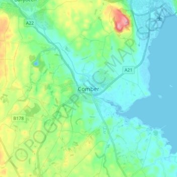
Nombre: Mapa topográfico Comber, altitud, relieve.
Altitud media: 36 m
Altitud mínima: -8 m
Altitud máxima: 159 m
Otros mapas topográficos
Haga clic en un mapa para ver su topografía, su altitud y su relieve.
Bangor
United Kingdom > Northern Ireland > County Down
Bangor, County Down, Northern Ireland, BT20 5AG, United Kingdom
Altitud media: 40 m
Ballylesson
United Kingdom > Northern Ireland > County Down
Ballylesson, County Down, Northern Ireland, BT8 8JU, United Kingdom
Altitud media: 61 m
Cloghy
United Kingdom > Northern Ireland > County Down
Cloghy, County Down, Northern Ireland, BT22 1HY, United Kingdom
Altitud media: 8 m
Ballymartin
United Kingdom > Northern Ireland > County Down > Ballymartin
Ballymartin, County Down, Northern Ireland, United Kingdom
Altitud media: 29 m
Moira
United Kingdom > Northern Ireland > County Down
Moira, County Down, Northern Ireland, BT67 0LE, United Kingdom
Altitud media: 59 m
Kernan Lake
United Kingdom > Northern Ireland > County Down
Kernan Lake, County Down, Northern Ireland, United Kingdom
Altitud media: 88 m
Drumaran Lake
United Kingdom > Northern Ireland > County Down > Gilford
Drumaran Lake, Gilford, County Down, Northern Ireland, United Kingdom
Altitud media: 65 m
Ballela
United Kingdom > Northern Ireland > County Down
Ballela, County Down, Northern Ireland, BT32 5PZ, United Kingdom
Altitud media: 136 m
Lawrencetown
United Kingdom > Northern Ireland > County Down
Lawrencetown, County Down, Northern Ireland, BT63 6DU, United Kingdom
Altitud media: 72 m
Loughbrickland
United Kingdom > Northern Ireland > County Down
Loughbrickland, County Down, Northern Ireland, BT32 3NH, United Kingdom
Altitud media: 97 m
Greyabbey
United Kingdom > Northern Ireland > County Down
Greyabbey, County Down, Northern Ireland, BT22 2NE, United Kingdom
Altitud media: 18 m
Drumaness
United Kingdom > Northern Ireland > County Down
Drumaness, County Down, Northern Ireland, BT24 8RL, United Kingdom
Altitud media: 74 m
Dollingstown
United Kingdom > Northern Ireland > County Down
Dollingstown, County Down, Northern Ireland, United Kingdom
Altitud media: 56 m
Bleary
United Kingdom > Northern Ireland > County Down > Bleary
Bleary, County Down, Northern Ireland, BT66 8TD, United Kingdom
Altitud media: 64 m
Banbridge
United Kingdom > Northern Ireland > County Down
Banbridge, County Down, Northern Ireland, BT32 3DB, United Kingdom
Altitud media: 90 m
Newtownards
United Kingdom > Northern Ireland > County Down
Newtownards, County Down, Ulster, Northern Ireland, BT23 4FA, United Kingdom
Altitud media: 50 m
Lough Erne
United Kingdom > Northern Ireland > County Down
Lough Erne, County Down, Northern Ireland, United Kingdom
Altitud media: 86 m
Dromara
United Kingdom > Northern Ireland > County Down
Dromara, County Down, Northern Ireland, BT25 2HX, United Kingdom
Altitud media: 149 m
Stormont Estate
United Kingdom > Northern Ireland > County Down > Dundonald
Stormont Estate, Dundonald, County Down, Ulster, Northern Ireland, United Kingdom
Altitud media: 64 m
Ballygowan
United Kingdom > Northern Ireland > County Down
Ballygowan, County Down, Ulster, Northern Ireland, BT23 6HB, United Kingdom
Altitud media: 67 m
Dromore
United Kingdom > Northern Ireland > County Down
Dromore, County Down, Ulster, Northern Ireland, BT25 1BD, United Kingdom
Altitud media: 106 m
Groomsport
United Kingdom > Northern Ireland > County Down
Groomsport, County Down, Northern Ireland, BT19 6JR, United Kingdom
Altitud media: 10 m
Ballyroney
United Kingdom > Northern Ireland > County Down
Ballyroney, County Down, Ulster, Northern Ireland, United Kingdom
Altitud media: 85 m
Holywood
United Kingdom > Northern Ireland > County Down
Holywood, County Down, Northern Ireland, BT18 9AE, United Kingdom
Altitud media: 44 m
Seapatrick
United Kingdom > Northern Ireland > County Down > Banbridge
Seapatrick, Banbridge, County Down, Ulster, Northern Ireland, United Kingdom
Altitud media: 89 m
Mourne Mountains Middle
United Kingdom > Northern Ireland > County Down
Mourne Mountains Middle, County Down, Northern Ireland, United Kingdom
Altitud media: 348 m
Dundonald
United Kingdom > Northern Ireland > County Down
Dundonald, County Down, Northern Ireland, BT16 1RH, United Kingdom
Altitud media: 80 m
Lagan Valley AONB
United Kingdom > Northern Ireland > County Down > Ballyskeagh
Lagan Valley AONB, Ballyskeagh, County Down, Ulster, Northern Ireland, United Kingdom
Altitud media: 66 m
Ballycultra
United Kingdom > Northern Ireland > County Down > Holywood
Ballycultra, Holywood, County Down, Ulster, Northern Ireland, United Kingdom
Altitud media: 69 m
Kilcoo
United Kingdom > Northern Ireland > County Down
Kilcoo, County Down, Northern Ireland, BT34 5HU, United Kingdom
Altitud media: 156 m
Ardglass
United Kingdom > Northern Ireland > County Down
Ardglass, County Down, Ulster, Northern Ireland, BT31 9SZ, United Kingdom
Altitud media: 217 m
Rathfriland
United Kingdom > Northern Ireland > County Down
Rathfriland, County Down, Ulster, Northern Ireland, BT34 5NH, United Kingdom
Altitud media: 97 m
Killough
United Kingdom > Northern Ireland > County Down
Killough, County Down, Ulster, Northern Ireland, BT30 7QQ, United Kingdom
Altitud media: 7 m
Gilford
United Kingdom > Northern Ireland > County Down
Gilford, County Down, Northern Ireland, BT63 6HH, United Kingdom
Altitud media: 43 m
Scarva
United Kingdom > Northern Ireland > County Down
Scarva, County Down, Northern Ireland, BT63 6LS, United Kingdom
Altitud media: 56 m
Katesbridge
United Kingdom > Northern Ireland > County Down
Katesbridge, County Down, Ulster, Northern Ireland, BT32 5PZ, United Kingdom
Altitud media: 99 m
Scrabo Tower
United Kingdom > Northern Ireland > County Down > Newtownards
Scrabo Tower, Scrabo Road, Newtownards, County Down, Northern Ireland, BT23 4XP, United Kingdom
Altitud media: 39 m
Burren River
United Kingdom > Northern Ireland > County Down > Castlewellan
Burren River, Castlewellan, County Down, Northern Ireland, BT31 9EB, United Kingdom
Altitud media: 85 m
Slieve Donard
United Kingdom > Northern Ireland > County Down
Slieve Donard, County Down, Northern Ireland, BT33 0HD, United Kingdom
Altitud media: 505 m
Newry
United Kingdom > Northern Ireland > County Down
Newry, County Down, Northern Ireland, United Kingdom
Altitud media: 73 m
Clonvaraghan
United Kingdom > Northern Ireland > County Down > Clonvaraghan
Clonvaraghan, County Down, Northern Ireland, BT31 9RH, United Kingdom
Altitud media: 125 m
Kilkeel
United Kingdom > Northern Ireland > County Down
Kilkeel, County Down, Northern Ireland, BT34 4BH, United Kingdom
Altitud media: 35 m
Blaris (Castlereagh Upper portion)
United Kingdom > Northern Ireland > County Down > Hillhall
Blaris (Castlereagh Upper portion), Hillhall, County Down, Northern Ireland, United Kingdom
Altitud media: 65 m
Cherryvalley
United Kingdom > Northern Ireland > County Down > Comber
Cherryvalley, Comber, County Down, Northern Ireland, United Kingdom
Altitud media: 10 m
Ardglass
United Kingdom > Northern Ireland > County Down > Ardglass
Ardglass, County Down, Northern Ireland, BT30 7SF, United Kingdom
Altitud media: 7 m
Kinallen
United Kingdom > Northern Ireland > County Down
Kinallen, County Down, Northern Ireland, BT25 2PW, United Kingdom
Altitud media: 124 m
Castlewellan
United Kingdom > Northern Ireland > County Down
Castlewellan, County Down, Ulster, Northern Ireland, BT31 9DQ, United Kingdom
Altitud media: 105 m
Rostrevor
United Kingdom > Northern Ireland > County Down
Rostrevor, County Down, Northern Ireland, BT34 3AZ, United Kingdom
Altitud media: 78 m
Warrenpoint
United Kingdom > Northern Ireland > County Down
Warrenpoint, County Down, Northern Ireland, BT34 3HS, United Kingdom
Altitud media: 102 m
Moneyreagh
United Kingdom > Northern Ireland > County Down
Moneyreagh, County Down, Ulster, Northern Ireland, BT23 6BE, United Kingdom
Altitud media: 95 m