
Gracias por apoyar a este sitio ❤️
Haz una donación
Haz una donación
Mapa topográfico Hohenstein
Haga clic en el mapa para ver la altitud.
Gracias por apoyar a este sitio ❤️
Haz una donación
Haz una donación
Acerca de este mapa
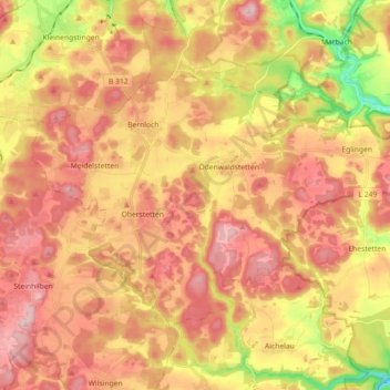
Nombre: Mapa topográfico Hohenstein, altitud, relieve.
Altitud media: 750 m
Altitud mínima: 614 m
Altitud máxima: 842 m
Gracias por apoyar a este sitio ❤️
Haz una donación
Haz una donación
Otros mapas topográficos
Haga clic en un mapa para ver su topografía, su altitud y su relieve.
Kleinengstingen
Germany > Baden-Württemberg > Landkreis Reutlingen > Kleinengstingen
Altitud media: 730 m
Engstingen
Germany > Baden-Württemberg > Landkreis Reutlingen
Engstingen is located on the northern edge of the Swabian Jura, at 680–750 metres (2,230–2,460 ft) altitude on the Alb plateau near the Alb edge in the valley of Ur-Lauter, about 15 km south of the town Reutlingen.
Altitud media: 738 m
Gracias por apoyar a este sitio ❤️
Haz una donación
Haz una donación