
Mapa topográfico Vanderbilt
Mapa interactivo
Haga clic en el mapa para ver la altitud.
Acerca de este mapa
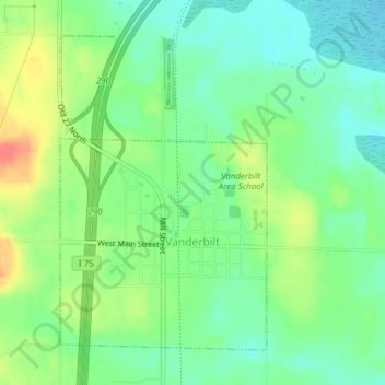
Nombre: Mapa topográfico Vanderbilt, altitud, relieve.
Altitud media: 334 m
Altitud mínima: 313 m
Altitud máxima: 369 m
Otros mapas topográficos
Haga clic en un mapa para ver su topografía, su altitud y su relieve.
Chester Township
United States > Michigan > Otsego County
Chester Township, Otsego County, Michigan, United States
Altitud media: 392 m
Charlton Township
United States > Michigan > Otsego County
Charlton Township, Otsego County, Michigan, 49751, United States
Altitud media: 368 m
Apache Lake
United States > Michigan > Otsego County
Apache Lake, Bagley Township, Otsego County, Michigan, United States
Altitud media: 392 m
Pigeon River Country State Forest
United States > Michigan > Otsego County
Pigeon River Country State Forest, Otsego County, Michigan, United States
Altitud media: 289 m
Gaylord
United States > Michigan > Otsego County > Gaylord
Gaylord, Otsego County, Michigan, United States
Altitud media: 401 m